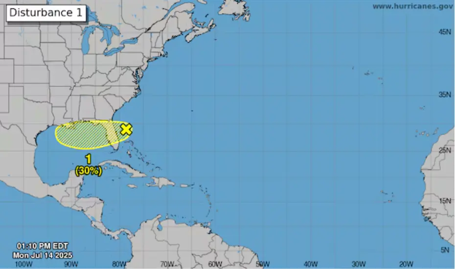
It began like most Florida mornings — humid, quiet, and deceivingly calm. But just off the east coast, something was stirring. “Forecasters eye area near Florida” wasn’t just a weather update — it was a warning whispered between radar signals. A low-pressure system, crouched in the Atlantic, had started its slow crawl across the state, dragging a curtain of rain toward the Tampa Bay area.
By Monday afternoon, the National Hurricane Center placed odds at 20% for the system to develop into something more sinister by Wednesday, and 30% over the week. The numbers may seem modest, but the storm’s effects were already materializing — not in distant forecasts but on Tampa’s own doorstep.
Rain, Thunder, and the Whisper of Floods
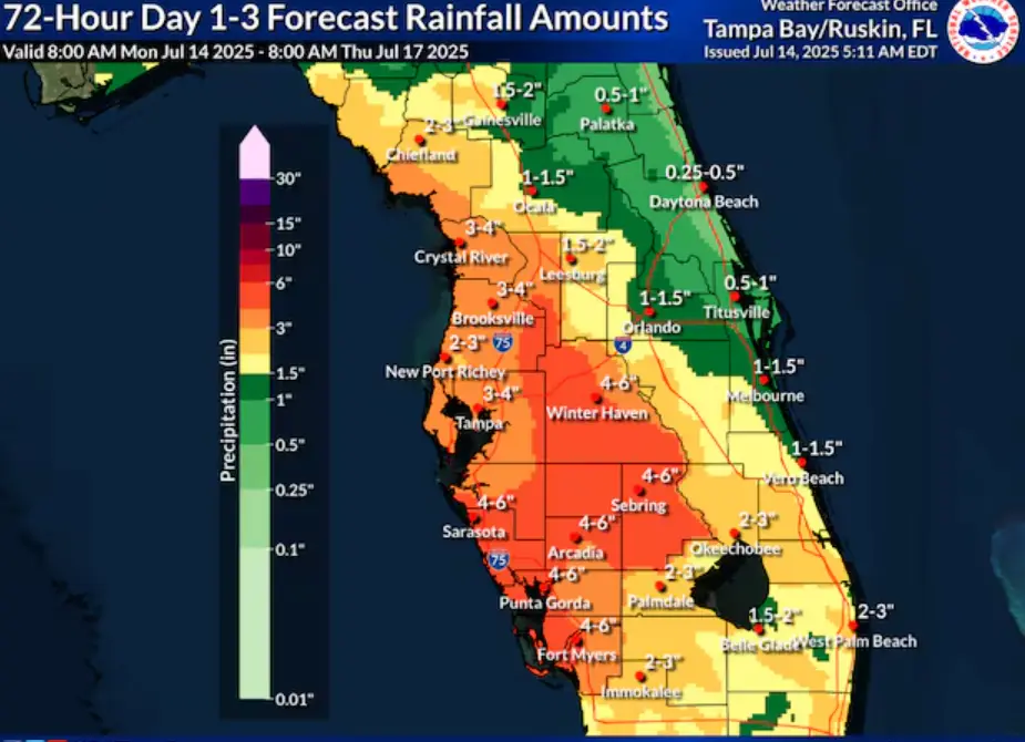
Christianne Pearce, meteorologist with the National Weather Service, spoke the kind of truth that sinks in slowly. “Our rain chances are definitely going to be on the high side,” she said, her voice crisp over the static of uncertainty. And high they were — with an 80% chance of rain through Wednesday, the city was bracing for up to 4 inches in just days.
Showers and thunderstorms had already begun their roll across Florida by Monday morning. The atmosphere churned, restless. According to the National Weather Service, storms may come bearing gusty winds, frequent lightning, and torrential downpours — a recipe for street flooding, especially in low-lying areas that are no strangers to pooling water.
From Dry Spells to Drenched Streets
It may seem ironic, but Tampa Bay — despite this approaching deluge — has been officially categorized as “abnormally dry” by the U.S. Drought Monitor. The region’s parched ground, baked by earlier months, may welcome the rain — at first. But like a sponge pushed past its limit, too much too fast could turn thirst into flash flooding.
Meteorologists expect the Alafia River and Little Manatee River in Hillsborough to reach minor flood stage by Thursday, before eventually receding. For some, it’s just nature’s rhythm. For others, it’s a threat. Because in Florida, water doesn’t knock — it barges in.
Eyes on the Gulf: The System’s Next Move
By late Tuesday, the system is expected to push into the northeastern Gulf of Mexico, where warm waters and atmospheric conditions might stir it into a stronger force. It doesn’t need to become a named storm to cause damage — sometimes, it’s the quiet ones that drench the soul.
The National Hurricane Center remains vigilant, updating forecasts in real-time on its official site and across its social media channels. As locals share videos of flooded roads and skies split by lightning, meteorologists watch the system’s westward crawl, calculating not just where it’s going — but what it might become.
A Return to the Usual, or Something Else?
By Thursday, Tampa Bay is expected to fall back into its seasonal rhythm: the late afternoon thunderstorms, the stifling heat, the blinding sunlight between bursts of rain. But something about this week feels different — like the calm is just a chapter break, not the story’s end.
Pearce mentioned it best: “We’re getting deep into our rainy season now.” The drought may fade, but residents are urged not to let their guard down. Because in Florida, the skies may clear — but the danger always lingers just behind the clouds.
Stay Informed, Stay Safe
The Tampa Bay Times continues to monitor the situation closely through its Environment Hub, a 2025 initiative focusing on Florida’s most pressing challenges. To support ongoing environmental reporting, readers can contribute to the journalism fund here.
For hourly updates, residents are encouraged to check:
- National Weather Service Tampa Bay
- Tampa Bay Times Weather Page
- City of Tampa Emergency Management Twitter
Stay dry, stay cautious… and watch the skies.
Something’s Coming…
And it’s not just the rain. The whispers are already circling — another tropical wave forming in the Atlantic, another ghost in the weather machine. Want to know what’s creeping just beyond the horizon? Stick with us.
Are you on social media? Check out our profile for more local news! Follow @TampaLatest for up-to-the-minute updates in Tampa, Florida.